-
1 subsidence of rocks
Англо-русский словарь нормативно-технической терминологии > subsidence of rocks
-
2 subsidence of rocks
Большой англо-русский и русско-английский словарь > subsidence of rocks
-
3 subsidence of rocks
Англо-русский словарь нефтегазовой промышленности > subsidence of rocks
-
4 subsidence of rocks
Нефть: оседание горных пород -
5 compression subsidence of rocks
Англо-русский словарь нормативно-технической терминологии > compression subsidence of rocks
-
6 compression subsidence of rocks
Большой англо-русский и русско-английский словарь > compression subsidence of rocks
-
7 compression subsidence of rocks
Англо-русский словарь нефтегазовой промышленности > compression subsidence of rocks
-
8 compression subsidence of rocks
Универсальный англо-русский словарь > compression subsidence of rocks
-
9 subsidence
* * *
проседание, опускание породы.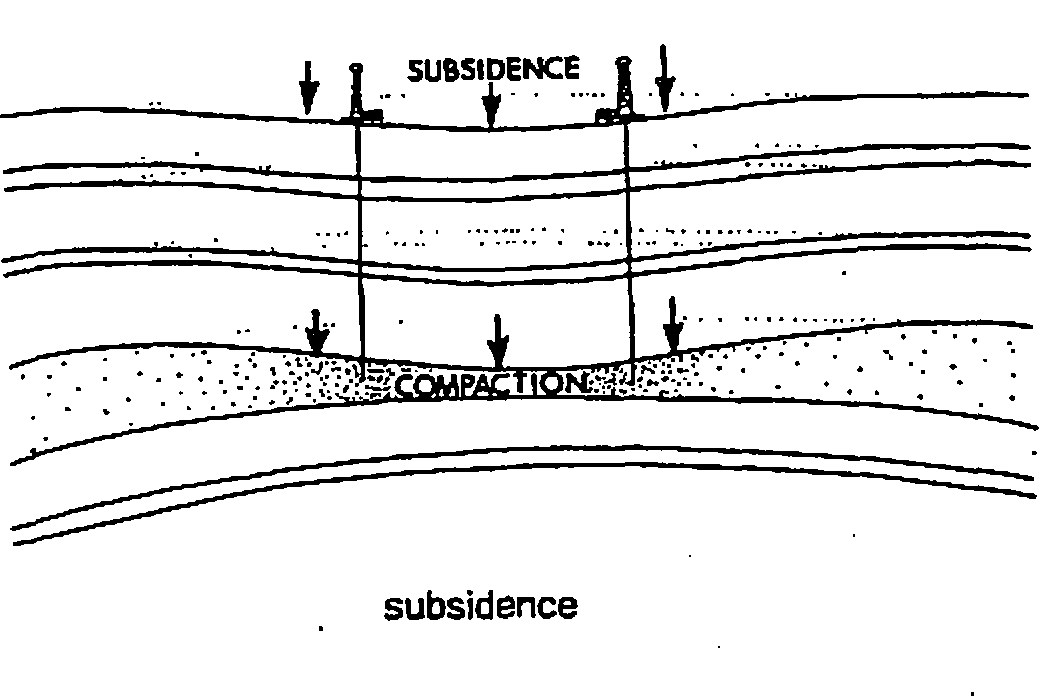
* * *
проседание геол.)
* * *
1) осадок2) осаждение3) оседание•- compression subsidence of rocks* * *• оседаниеАнгло-русский словарь нефтегазовой промышленности > subsidence
-
10 compression setting of rocks
Англо-русский словарь нормативно-технической терминологии > compression setting of rocks
-
11 оседание горных пород
Большой англо-русский и русско-английский словарь > оседание горных пород
-
12 fall
fɔ:l
1. сущ.
1) падение;
спуск, снижение to have, take a fall ≈ падать a bad, nasty fall ≈ неудачное падение a free fall( of a parachutist) ≈ свободное падение( парашютиста) The net broke the tightrope walker's fall. ≈ Сетка смягчила падение канатоходца. Syn: descent, drop, falling, dropping, spill, tumble, slip, plummet
2) падение, сбрасывание;
выпадение (осадков) the fall of leaves ≈ сбрасывание листьев a fall of snow ≈ выпадение снега Syn: dropping
3) амер. осень early fall ≈ ранняя осень late fall ≈ поздняя осень in (the) fall ≈ осенью Syn: autumn
4) обыкн. мн. водопад Niagara Falls ≈ Ниагарский водопад We could see the spray from the falls downriver. ≈ Мы видели водяные брызги от водопада вниз по реке. Syn: waterfall, cascade, cataract
5) впадение( реки)
6) а) рождение( обыкн. о ягнятах), окот б) помет, выводок
7) выпадение (волос и т. п.)
8) количество сваленного леса
9) нечто свободно свисающее, ниспадающее а) покрывало, вуаль б) ниспадающий воротник в) широкий передний карман на брюках г) три лепестка (обычно свисающих) ириса д) длинная шерсть на морде у некоторых пород собак е) шиньон из длинных волос
10) а) упадок, закат б) падение, поражение, капитуляция the fall of Troy ≈ падение Трои The fall of the city followed heavy bombardment. ≈ Сдаче города предшествовала сильная бомбардировка. Syn: surrender, capitulation, overthrow, capture, downfall, collapse, defeat
11) моральное падение;
потеря чести;
потеря невинности The play was about the fall of an honest man. ≈ В пьесе говорилось о моральном падении честного человека. Fall of man ≈ грехопадение Syn: corruption, ruin, loss of innocence, deviation from virtue, slip;
downfall
12) спорт а) прижатие соперника спиной к мату (в борьбе) б) схватка, раунд
13) обрыв, склон, откос (холма) ;
скат, спуск Syn: declivity
14) снижение, спад;
падение, понижение (цен), обесценение Yesterday saw a sudden fall in stock prices. ≈ Вчера произошло резкое падение биржевого курса. Syn: drop, decline, lowering, sinking, diminution, decrease, reduction, slump, depreciation;
ebb, subsidence, wane
15) муз. каданс
16) нисходящая интонация( в речи)
17) тех. напор, высота напора
18) тех. канат или цепь подъемного блока (обыкн. block and fall)
19) мор. фал ∙ pride will have a fall посл. ≈ гордыня до добра не доводит
2. гл.;
прош. вр. - fell, прич. прош. вр. - fallen
1) падать to fall off a table ≈ упасть со стола to fall on one's back ≈ падать на спину The apple fell from the tree. ≈ Яблоко упало с дерева. He fell down the stairs. ≈ Он упал с лестницы. Syn: drop, drop down, tumble, topple, collapse, crash down
2) опадать( о листьях) ;
выпадать, идти( об осадках)
3) спускаться, наступать Night fell. ≈ Спустилась ночь.
4) впадать( о реке)
5) рождаться( о ягнятах и т. п.)
6) выпадать (о волосах и т. п.)
7) рубить, валить (деревья) ;
валиться( о дереве)
8) ниспадать;
(свободно) падать (об одежде, волосах и т. п.) Her dress falls in pleats from the waist. ≈ Ее платье спадает от талии свободными складками. Syn: extend down, hang down, slope, droop, cascade;
descend, drop
9) пасть, сдаться, капитулировать;
погибнуть On the third day of the attack, the town fell. ≈ На третий день город пал. Syn: surrender, be captured, be overthrown, be defeated, be taken, pass into enemy hands, collapse, capitulate, succumb;
be destroyed, come to destruction
10) пасть морально, грешить How many innocents have fallen and become hardened sinners! ≈ Сколько невинных пали и стали неисправимыми грешниками! Syn: transgress, give in to temptation, succumb, lapse, sin, depart from rectitude, err
11) браться, приниматься( за что-л.), начинать делать( что-л.) We shall not fall to send our reply. ≈ Мы не замедлим послать наш ответ.
12) приходиться, падать, происходить, иметь место My birthday falls on Sunday. ≈ Мое рождение попадает на воскресенье. Syn: occur, come to pass, happen, take place, come off, come around
13) падать, понижаться, уменьшаться The temperature has fallen. ≈ Температура упала;
похолодало. My spirits fell. ≈ Мое настроение упало. The cost of meat finally fell. ≈ Цены на мясо наконец снизились. Syn: decline, come down, become less, decrease, diminish, become lower, cheapen, depreciate
14) стихать, ослабевать( о ветре и т. п.)
15) потерпеть крах;
разориться
16) обваливаться, оседать
17) попадать to fall into disfavor ≈ попасть в немилость to fall into disrepute ≈ иметь дурную славу to fall into place ≈ добраться до места to fall into a trap ≈ попасть в ловушку to fall under a train ≈ попадать под поезд to fall under smb. 's influence ≈ попадать под чье-л. влияние
18) делиться, распадаться to fall into three categories ≈ делиться на три категории
19) (употребляется как глагол-связка) становиться to fall asleep ≈ заснуть to fall astern ≈ отстать to fall dead ≈ упасть замертво to fall dumb ≈ онеметь to fall silent ≈ замолчать to fall victim (to) ≈ пасть жертвой ∙ fall about fall abreast of fall across fall among fall apart fall away fall back fall back up fall back on fall behind fall below fall down fall for fall foul fall in fall in with fall into fall off fall on fall out fall over fall through fall to fall under fall upon fall within to fall into line воен. ≈ построиться, стать в строй let fall! мор. ≈ отпускай! fall from grace fall in love fall over oneself падение - a * from one's horse падение с лошади - the * of an apple падение яблока - the * of the hammer удар молотка (на аукционе) - intentional * (спортивное) преднамеренное нападение - pin * падение на обе лопатки (борьба) - to take a * быть сбитым с ног падение, закат - the rise and * of the Roman Empire расцвет и упадок Римской империи понижение, падение;
спад - * in temperature понижение /падение/ температуры - the rise and * of the waves волнение моря /воды/ - a * in prices падение цен обыкн. pl водопад - Niagara Falls Ниагарский водопад уклон, обрыв, склон ( холма) - the * of the plain понижение равнины выпадение (волос, зубов) (американизм) осень - * fashions осенние моды - * overcoat( мужское) осеннее пальто выпадение (осадков и т. п.) - a heavy * of rain сильный дождь, ливень - a two-inch * of snow снежный покров в два дюйма толщиной - a * of rocks blocked the road камнепад завалил дорогу - * of leaves опадение листвы впадение реки окот, рождение (ягнят и т. п.) выводок, помет рубка леса срубленный лес покрывало, вуаль ниспадающий воротник накладные волосы в виде "конского хвоста";
шиньон из длинных волос (спортивное) круг, схватка, раунд - he won two *s out of three он выиграл две схватки из трех - to try a * with smb. побороться /померяться силами/ с кем-л. (техническое) напор, высота напора (техническое) канат подъемного блока (обыкн. block and *) (морское) фал (музыкальное) каданс - (the F.) (религия) грехопадение, первородный грех (тж. a * from grace) - before the F. до грехопадения > to ride for a * неосторожно ездить верхом;
действовать безрассудно, неосмотрительго, во вред самому себе > pride will have a * кто высоко заносится, тот низко падает;
всякой гордыне приходит конец падать - to * to the ground упасть на землю - I fell and hurt my knee я упал и ушиб колено - to * out of a window вывалиться из окна - to * down a precipice сорваться с обрыва - to * over a chair in the dark наткнуться на стул в темноте и упасть - to * full length упасть плашмя, растянуться (во весь рост) - to * on (to) one's knees пасть на колени опускаться, спускаться - the curtain *s занавес падает - her hair *s llosely on her shoulders волосы (свободно) спадают ей на плечи - dress *ing freely платье, ниспадающее свободными складками - to * in smb.'s estimation упасть в чьих-л. глазах низко опускаться, склоняться - her head fell on his shoulder она склонила голову ему на плечо - his eyes fell он опустил глаза наступать, опускаться - darkness fell стемнело - a mist fell опустился туман - night is *ing fast надвигается ночь охватывать, одолевать - sleep fell upon them их свалил /одолел/ сон - fear fell upon him его охватил страх падать, понижаться - the temperature fell температура упала - the glass has *en барометр упал - prices have *en цены упали - the market is *ing цены на рынке падают - stocks fell several points акции упали на несколько пунктов - the river has fallen уровень воды в реке понизился, вода в реке спала стихать, ослабевать - the wind fell ветер стих - here his voice fell он заговорил тише;
он сказал это упавшим голосом - the flames rose and fell пламя то разгоралось, то затихало - the music rose and fell музыка звучала то громче, то тише - his anger suddenly fell его гнев внезапно иссяк - the conversation fell for a few minutes разговор стих на несколько минут ухудшаться, портиться - my spirits fell у меня упало настроение пасть;
погибнуть - to * in (a) battle пасть в бою - to * by the sword пасть от меча - two elephants fell to his gun он убил двух слонов - the fortress fell крепость пала - the Cabinet fell правительство пало дохнуть - large numbers of cattle fell in the drought по время засухи был большой падеж скота устремляться, направляться - when his eye fell on me когда он увидел меня - his eye fell on a misprint опечатка бросилась ему в глаза - the sunlight fell upon the mountain лучи солнца осветили гору - music fell on his ear он услышал музыку, до него донеслась музыка опускаться;
идти под уклон - the plain fell to the north равнина понижалась к северу рушиться, обваливаться;
оседать - many houses fell in the earthquake во время землетрясения было разрушено много домов - the bank fell берег осел (on, upon) распространяться, ложиться( на кого-л., что-л.) ;
падать (на кого-л., что-л.) - suspicion fell on him подозрение пало на него - the lot fell on him жребий пал на него - the responsibility *s on me ответственность падает /ложится/ на меня - the expense fell on him расплачиваться пришлось ему - the accent *s (up) on the last syllabe ударение падает на последний слог - May Day this year *s on Monday первомайский праздник в этом году приходится на понедельник (to) выпадать (на чью-л. долю) ;
доставаться( кому-л.) - to * to smb.'s share /to smb.'s lot/ доставаться, выпадать на чью-л. долю - it fell to me to break the news to her на мою долю выпало /мне пришлось/ сообщить ей эту новость - his property *s to his wife его имущество переходит к жене /наследует жена/ - it fell upon me to open the exhibition мне довелось /пришлось/ открывать выставку срываться с уст - not a word fell from his lips с его уст не сорвалось ни единого слова - to let * a word проронить слово - the excellent advice that fell from his lips превосходные советы, которые он раздавал - I agree with what has *en from the last speaker я согласен с тем, что сказал последний оратор (сленг) угодить в тюрьму - he fell twice он два раза сидел пасть (о женщине) ;
утратить целомудрие опадать (о листьях и т. п.;
тж. * off) - blossoms * from the trees цвет опадает с деревьев - the petals are *ing off the flower цветок осыпается выпадать (о волосах, зубах;
часто * out) - a child's first teeth * у ребенка выпадают молочные зубы - his hair is *ing у него выпадают /лезут/ волосы идти, выпадать (о дожде, снеге) - rain is *ing идет дождь - snow fell выпал снег впадать (о реке) - rivers that * into the sea реки, впадающие в море попадать (в ловушку и т. п.) - to * into a snare /a trap/ попасть в ловушку - to * into smb.'s clutches попасть в чьи-л. лапы - to * to temptation поддаться искушению распадаться (на части) - to * (in) to pieces, to * apart /asunder/ распадаться на части - the work *s into three divisions работа делится на три части - they fell into two factions они раскололись на две фракции западать( в голову) ;
приходить( на ум) - when this strange idea fell into his mind когда ему пришла на ум эта странная идея - it fell into my mind to write you a letter мне вдруг захотелось написать вам письмо рождаться (о ягнятах, щенятах и т. п.) - to fall across smb., smth. наталкиваться на кого-л., что-л.;
неожиданно встретить( кого-л.) ;
налететь, нарваться( на что-л., кого-л.) - to fall on /upon/ smb., smth. наталкиваться на кого-л., что-л.;
нападать, набрасываться, бросаться на кого-л., что-л. - she had *en on hard times для нее наступили тяжелые времена - to * upon smb.'s neck кинуться на шею кому-л. - to fall among smb. попадать в какое-л. общество - to * among evil companions попасть в дурную компанию - to * among thieves попасть в руки /в лапы/ грабителей /мошенников/;
(библеизм) попасться разбойникам - to fall under smth. подвергаться чему-л.;
испытывать что-л.;
подпадать под какую-л. категорию и т. п., входить в какую-л. группу и т. п. - to * under smb.'s displeasure заслужить чью-л. немилость, попасть у кого-л. в немилость - to * under suspicion попасть под подозрение - to * under smb.'s power попадать под чью-л. власть - these things do not * under human observation такие явления недоступны человеческому наблюдению - these facts * into another category эти факты относятся к другой категории - to fall within smth. входить в какие-л. границы, пределы и т. п.;
находиться в пределах, сфере чего-л. - to * within a certain sphere of influence находиться в определенной сфере влияния - this doesn't * within my province это вне моей компетенции - to fall in(to) a state приходить, впадать в какое-л. состояние;
доходить до какого-л. состояния;
оказываться в каком-л. положении - to * into rage впадать в ярость /в гнев/ - to * into error впасть в ошибку /в заблуждение/ - to * in love влюбиться - he *s in and out of love very easily он очень влюбчивый человек - to * into talk заговорить, разговориться - the custom fell into abuse этот обычай выродился - to * into a spin (авиация) войти в штопор - to * into disgrace /into disfavour/ впадать в немилость - to fall to (doing) smth. браться, приниматься за что-л., начинать делать что-л. - one night I fell to thinking of the past однажды ночью я задумался о прошлом - she fell to brooding again она снова стала грустить;
ею снова овладели грустные мысли - to fall for smb. (разговорное) увлечься кем-л., влюбиться в кого-л. - every girl *s for him все девушки без ума от него - to fall for smth. (разговорное) попасться на удочку - he at once fell for it он тотчас же попался на эту удочку - he fell for the trick он поддался обману, он попался на удочку как глагол-связка в составном именном сказуемом: - to * asleep засыпать - to * sick заболеть - to * dumb онеметь - to * silent замолчать - to * vacant освободиться - to * due подлежать оплате (о векселе и т. п.) - the rent *s due next Monday срок квартирной платы в будущий понедельник - to * a-laughing (устаревшее) расхохотаться > to * at hand надвигаться, приближаться > to * flat не иметь успеха, не удаться;
не произвести желаемого впечатления > his jokes all fell flat его шутки никого не развеселили > to * over one another doing smth. делать что-л. с чрезмерным усердием;
очень торопиться > to * all over oneself из кожи вон лезть;
стараться изо всех сил > to * foul (морское) столкнуться (с другим судном) ;
ссориться > to * from grace терять расположение;
грешить, сбиваться с пути истинного > to * into line (военное) построиться;
подчиниться, согласиться > to * into place вставать на (свое) место > when he told me his story all the facts I had known before fell into place когда он рассказал мне свою историю, все факты, известные мне и раньше, стали понятны > to * into a habit приобретать привычку, привыкать > to * out of a habit отвыкать > he fell out of the habit of smoking он отвык от курения > to * short (of) потерпеть неудачу;
не хватать;
не достигать цели > his income *s short of his expenditure by $500 его доходы на 500 долларов меньше, чем его расходы > our efforts have *en short наши усилия не увенчались успехом > to * on one's feet счастливо отделаться, удачно выйти из трудного положения > to * to the ground рушиться, оказываться бесполезным /безрезультатным/ > to * on one's face провалиться( с треском) ;
оскандалиться;
потерпеть фиаско > to * between two stools сесть между двух стульев > his face fell у него вытянулось лицо( редкое) ловушка (профессионализм) крик, издаваемый китобоями при виде кита охота на китов ~ into распадаться на;
the book falls into three parts книга распадается на три части ~ приходиться, падать;
доставаться;
his birthday falls on Monday день его рождения приходится на понедельник;
the expense falls on me расход падает на меня fall (обыкн. pl) водопад (напр., Niagara Falls) ~ впадать (о реке;
into - в) ~ впадение (реки) ~ выпадение (волос и т. п.) ~ выпадение осадков;
a heavy fall of rain ливень ~ гибнуть;
to fall in battle пасть в бою;
быть убитым;
the fortress fell крепость пала ~ глагол-связка становиться;
to fall dumb онеметь;
to fall silent замолчать;
to fall asleep заснуть ~ тех. канат или цепь подъемного блока (обыкн. block and fall) ~ количество сваленного леса ~ моральное падение;
потеря чести;
the Fall of man библ. грехопадение ~ тех. напор, высота напора ~ ниспадать;
(свободно) падать (об одежде, волосах и т. п.) ~ опускаться, падать;
the curtain falls занавес опускается;
the temperature has fallen температура упала;
похолодало;
my spirits fell мое настроение упало ~ опускаться ~ оседать, обваливаться ~ амер. осень ~ (fell;
fallen) падать, спадать, понижаться;
the Neva has fallen вода в Неве спала;
prices are falling цены понижаются ~ падать ~ падение;
снижение ~ падение ~ пасть морально ~ понижаться ~ понижение ~ потерпеть крах;
разориться ~ приходиться, падать;
доставаться;
his birthday falls on Monday день его рождения приходится на понедельник;
the expense falls on me расход падает на меня ~ рождаться (о ягнятах и т. п.) ~ рубить (лес) ;
валить (дерево) ;
валиться (о дереве) ;
fall about падать от хохота;
fall abreast of не отставать от;
идти в ногу с ~ снижаться ~ снижение ~ сникнуть;
her face fell ее лицо вытянулось ~ спад;
падение цен, обесценение ~ спад ~ спускаться, сходить;
night fell спустилась ночь ~ стихать (о ветре и т. п.) ~ спорт. схватка (в борьбе) ;
to try a fall (with smb.) бороться (с кем-л.) ~ уклон, обрыв, склон (холма) ;
скат, понижение профиля местности ~ уменьшаться ~ упадок, закат, потеря могущества ~ утратить власть ~ мор. фал;
pride will have a fall посл. = гордый покичился да во прах скатился;
спесь в добро не вводит, гордыня до добра не доведет ~ рубить (лес) ;
валить (дерево) ;
валиться (о дереве) ;
fall about падать от хохота;
fall abreast of не отставать от;
идти в ногу с ~ рубить (лес) ;
валить (дерево) ;
валиться (о дереве) ;
fall about падать от хохота;
fall abreast of не отставать от;
идти в ногу с ~ across встретить случайно;
fall among попасть случайно ~ across встретить случайно;
fall among попасть случайно to ~ astern мор. отстать;
to fall due подлежать уплате( о векселе) ~ away покидать, изменять ~ away спадать;
уменьшаться ~ away чахнуть, сохнуть ~ back отступать ~ back (up) on обращаться( к кому-л.) в нужде ~ back (up) on прибегать( к чему-л.) to ~ dead упасть замертво;
to fall victim (to) пасть жертвой ~ down разг. потерпеть неудачу;
to fall down on one's work не справиться со своей работой ~ due for payment подлежать оплате по сроку ~ глагол-связка становиться;
to fall dumb онеметь;
to fall silent замолчать;
to fall asleep заснуть to ~ flat не произвести ожидаемого впечатления;
his joke fell flat его шутка не имела успеха flat: ~ плоско;
врастяжку, плашмя;
to fall flat упасть плашмя ~ скучный, унылый;
безжизненный;
неэнергичный;
неостроумный;
невразумительный;
to fall flat не произвести впечатления ~ for влюбляться;
чувствовать влечение;
поддаваться( чему-л.) ~ for попадаться на удочку to ~ foul of ссориться;
нападать;
to fall over oneself лезть из кожи вон to ~ foul of мор. сталкиваться to ~ from grace впасть в ересь;
to fall into line воен. построиться, стать в строй;
to fall into line with подчиняться, соглашаться с to ~ from grace согрешить ~ in истекать( о сроке аренды, долга, векселя) ~ in проваливаться, обрушиваться ~ in (with) случайно встретиться, столкнуться ~ in воен. становиться в строй, строиться ~ in (with) уступать;
соглашаться, быть в согласии( с кем-л.) ~ гибнуть;
to fall in battle пасть в бою;
быть убитым;
the fortress fell крепость пала ~ in interest rates понижение процентных ставок to ~ in love влюбляться;
he falls in and out of love too often он непостоянен в любви love: ~ влюбленность;
to be in love (with) быть влюбленным (в) ;
to fall in love (with) влюбиться (в) ;
to fall out of love( with smb.) разлюбить( кого-л.) ~ in oil prices снижение цен на нефть ~ in prices падение цен ~ in prices снижение уровня цен ~ in quotation снижение курса ~ in value снижение стоимости ~ in value of money обесценивание денег ~ into начинать (что-л)., приниматься (за что-л.) ~ into относиться к;
to fall into the category относиться к категории, подпадать под категорию ~ into приходить в определенное состояние: to fall into a rage впадать в бешенство ~ into распадаться на;
the book falls into three parts книга распадается на три части ~ into приходить в определенное состояние: to fall into a rage впадать в бешенство to ~ from grace впасть в ересь;
to fall into line воен. построиться, стать в строй;
to fall into line with подчиняться, соглашаться с to ~ from grace впасть в ересь;
to fall into line воен. построиться, стать в строй;
to fall into line with подчиняться, соглашаться с ~ into относиться к;
to fall into the category относиться к категории, подпадать под категорию ~ of hammer удар молотка (на аукционе) ~ моральное падение;
потеря чести;
the Fall of man библ. грехопадение ~ off мор. не слушаться руля( о корабле) ~ off отпадать;
отваливаться ~ off уменьшаться;
ослабевать ~ on выпадать на (чью-л.) долю ~ on нападать;
набрасываться ~ on приступать( к чему-л.) to ~ on one's face = провалиться с треском, оскандалиться;
to fall to pieces развалиться ~ out выпадать ~ out воен. выходить из строя ~ out случаться;
it so fell out that случилось так, что ~ out ссориться ~ over споткнуться( обо что-л.) ~ over увлекаться to ~ over one another, to ~ over each other драться, бороться, ожесточенно соперничать друг с другом;
let fall! мор. отпускай! to ~ over one another, to ~ over each other драться, бороться, ожесточенно соперничать друг с другом;
let fall! мор. отпускай! to ~ foul of ссориться;
нападать;
to fall over oneself лезть из кожи вон ~ глагол-связка становиться;
to fall dumb онеметь;
to fall silent замолчать;
to fall asleep заснуть ~ through провалиться;
потерпеть неудачу ~ to выпадать, доставаться;
to fall to (smb.'s) lot выпадать на (чью-л.) долю ~ to выпадать ~ to доставаться ~ to нападать ~ to начинать, приниматься (за что-л.) ~ to приниматься за еду ~ to выпадать, доставаться;
to fall to (smb.'s) lot выпадать на (чью-л.) долю to ~ on one's face = провалиться с треском, оскандалиться;
to fall to pieces развалиться ~ to the ground оказаться безрезультатным ground: ~ земля, почва;
грунт;
to fall to the ground упасть;
перен. рушиться (о надежде и т. п.) ;
to take ground приземлиться ~ under подвергаться ~ under подпадать;
to fall under item 26 подпадать под действие раздела 26 ~ under подпадать;
to fall under item 26 подпадать под действие раздела 26 ~ upon нападать ~ upon наталкиваться to ~ dead упасть замертво;
to fall victim (to) пасть жертвой ~ гибнуть;
to fall in battle пасть в бою;
быть убитым;
the fortress fell крепость пала to ~ in love влюбляться;
he falls in and out of love too often он непостоянен в любви ~ выпадение осадков;
a heavy fall of rain ливень ~ сникнуть;
her face fell ее лицо вытянулось ~ приходиться, падать;
доставаться;
his birthday falls on Monday день его рождения приходится на понедельник;
the expense falls on me расход падает на меня to ~ flat не произвести ожидаемого впечатления;
his joke fell flat его шутка не имела успеха ~ out случаться;
it so fell out that случилось так, что to ~ over one another, to ~ over each other драться, бороться, ожесточенно соперничать друг с другом;
let fall! мор. отпускай! ~ опускаться, падать;
the curtain falls занавес опускается;
the temperature has fallen температура упала;
похолодало;
my spirits fell мое настроение упало ~ (fell;
fallen) падать, спадать, понижаться;
the Neva has fallen вода в Неве спала;
prices are falling цены понижаются ~ спускаться, сходить;
night fell спустилась ночь night: by ~ под покровом ночи;
on nights разг. по ночам;
night fell наступила ночь price ~ падение курса ценных бумаг price ~ снижение цен ~ (fell;
fallen) падать, спадать, понижаться;
the Neva has fallen вода в Неве спала;
prices are falling цены понижаются ~ мор. фал;
pride will have a fall посл. = гордый покичился да во прах скатился;
спесь в добро не вводит, гордыня до добра не доведет ~ опускаться, падать;
the curtain falls занавес опускается;
the temperature has fallen температура упала;
похолодало;
my spirits fell мое настроение упало ~ спорт. схватка (в борьбе) ;
to try a fall (with smb.) бороться (с кем-л.)
См. также в других словарях:
subsidence doline — A closed karst depression formed due to local subsidence of the surface rocks and/or soil into cavities formed by widespread dissolution or local collapse of caves. The type of subsidence doline formed by downwashing of the soil cover is… … Lexicon of Cave and Karst Terminology
Secondary rocks — Secondary Sec ond*a*ry, a. [Cf. F. secondaire, L. secundaire. See {Second}, a.] 1. Succeeding next in order to the first; of second place, origin, rank, etc.; not primary; subordinate; not of the first order or rate. [1913 Webster] Wheresoever… … The Collaborative International Dictionary of English
оседание горных пород под давлением — — [http://slovarionline.ru/anglo russkiy slovar neftegazovoy promyishlennosti/] Тематики нефтегазовая промышленность EN compression setting of rockscompression subsidence of rocks … Справочник технического переводчика
оседание горных пород — — [http://slovarionline.ru/anglo russkiy slovar neftegazovoy promyishlennosti/] Тематики нефтегазовая промышленность EN subsidence of rocks … Справочник технического переводчика
Sedimentary rock — Middle Triassic marginal marine sequence of siltstones (below) and limestones (above), Virgin Formation, southwestern Utah, USA Sedimentary rock are types of rock that are formed by the deposition of material at the Earth s surface and within… … Wikipedia
GEOGRAPHICAL SURVEY — Names The name Ereẓ Israel (the Land of Israel) designates the land which, according to the Bible was promised as an inheritance to the Israelite tribes. In the course of time it came to be regarded first by the Jews and then also by the… … Encyclopedia of Judaism
Asia — /ay zheuh, ay sheuh/, n. a continent bounded by Europe and the Arctic, Pacific, and Indian oceans. 2,896,700,000; ab. 16,000,000 sq. mi. (41,440,000 sq. km). * * * I Largest continent on Earth. It is bounded by the Arctic Ocean, the Pacific Ocean … Universalium
Geology of Alderley Edge — Infobox Mountain Name = Alderley Edge Photo = Stormy Point 1993.jpg Caption = Stormy Point Elevation = 183 m (600 ft) Location = Cheshire, ENG Range = Prominence = Coordinates = Topographic OS Landranger 118 Grid ref UK = SJ870760 Grid ref… … Wikipedia
Africa — /af ri keuh/, n. 1. a continent S of Europe and between the Atlantic and Indian oceans. 551,000,000; ab. 11,700,000 sq. mi. (30,303,000 sq. km). adj. 2. African. * * * I Second largest continent on Earth. It is bounded by the Mediterranean Sea,… … Universalium
Tertiary Period — Interval of geologic time, 65–1. 8 million years ago. It constitutes the first of the two periods of the Cenozoic Era, the second being the Quaternary. The Tertiary has five subdivisions: (from oldest to youngest) the Paleocene, Eocene, Oligocene … Universalium
Earth Sciences — ▪ 2009 Introduction Geology and Geochemistry The theme of the 33rd International Geological Congress, which was held in Norway in August 2008, was “Earth System Science: Foundation for Sustainable Development.” It was attended by nearly… … Universalium